Support

Help with the app

How to get started, how to get a better GPS signal, and answers to common questions.

Get in touch

Email us at

Tell us which device you're using, the version of iOS, and what happened. Please don't send personal details we don't need. The Data Policy says how we handle support email.

Getting started

Three steps, in the order you'll use them.

Steps
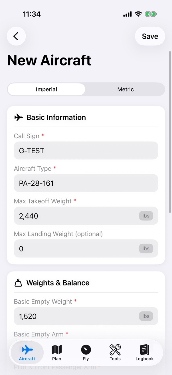
The New Aircraft form for G-TEST, a PA-28-161, in imperial units: a maximum take-off weight of 2,440 pounds, a basic empty weight of 1,520 pounds, and the weights and balance arms below.

Step 1 of 3

Set up your aircraft

In the Aircraft tab, tap Add Profile. Enter the call sign, type, weights and arms, and the cruise TAS and fuel rate, then tap Save.

Open the profile and tap Edit, then Edit Envelope. Tap the chart to place the CG envelope's points, or tap Scan Chart to read them from a photo of your POH.

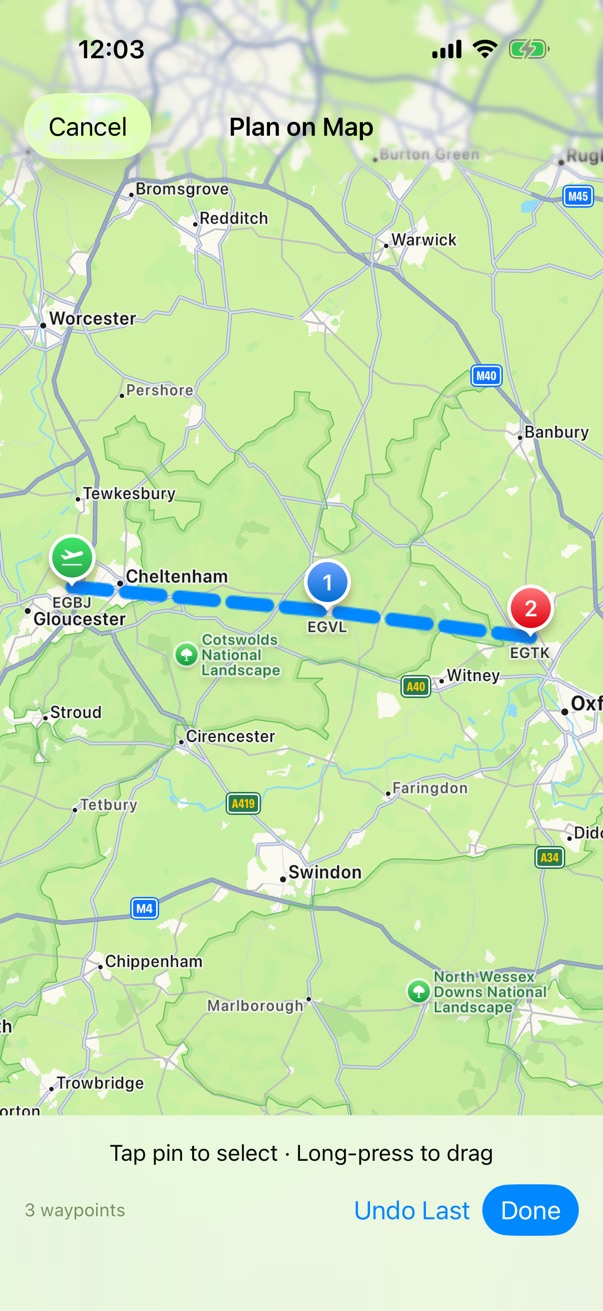
Plan on Map: the route from EGBJ through waypoint EGVL to EGTK drawn on Apple Maps, with buttons to undo the last waypoint or finish.

Step 2 of 3

Make a flight plan

In the Plan tab, open Flight Plans and tap New Flight Plan. Enter the departure and destination ICAO codes and choose the aircraft.

Tap Plan Route on Map, tap the map to place your turning points and destination, then tap Done. Add each leg's wind and altitude, tap Save Legs, enter the fuel, and tap Save.

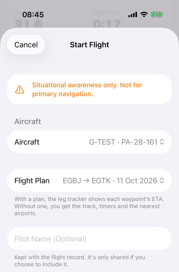
The Start Flight screen: the note that the app is for situational awareness only, the aircraft G-TEST, a PA-28-161, the flight plan EGBJ to EGTK, and an optional pilot name.

Step 3 of 3

Record a flight

In the Fly tab, open Fly and tap Start Flight. Choose the aircraft and the flight plan. The first time, read the note about mounting your device and turn on I Understand. Then tap Start Flight (Off-Blocks Now). The app asks to use your location while it records.

On blocks, tap Finish (On-Blocks), then Add to Logbook to check and save the entry.

Improving GPS reception

What helps a phone or tablet keep a GPS fix in a light aircraft. The same tips are in the app, under the GPS card.

Situational awareness only. Not for primary navigation.

  • Give it a view of the sky

    Mount the device near the windscreen with as much open sky above it as possible. Under the panel coaming, in a bag or under the wing root, the signal is much weaker.

  • Some windscreens and cases block GPS

    Heated or metallised windscreens, and thick or metal cases, can block the signal. If the fix is poor, try another position or remove the case.

  • Get a fix before you taxi

    Open the app and start recording on the ground with a clear view of the sky, and wait for a good fix before you move. A cold start can take a minute or more.

  • Wi-Fi-only iPads have no GPS

    An iPad without a mobile data connection has no GPS receiver, so it only knows roughly where it is from Wi-Fi.

  • An external GPS works automatically

    A paired Bluetooth GPS receiver made for iPhone and iPad gives fixes to every app with no set-up. The GPS card shows External GPS while it's in use.

When the signal is lost, ground speed and track are held, then the position is estimated for up to 3 minutes from the last fix. Estimates are marked on screen, are never recorded, and aren't for navigation. Fly your planned heading and use your chart.

Questions

Does the app sync between my devices?

Yes, through your own iCloud account. Your aircraft, flight plans, logbook, recorded flights and settings are stored on your device and, if you're signed in to iCloud, in your own iCloud account, so they're available on your other devices. There's no separate account to create.

If something is still downloading from iCloud, the app says so, and you can change it once it has downloaded.

Where is my data kept?

On your device and, if you use iCloud, in your own iCloud account. The app has no accounts, analytics or tracking, and sends nothing to us. Your data leaves the app only when you choose to share it.

The Data Policy has the details.

How do I get the app on my Apple Watch?

The Watch app comes with the iPhone app. If it isn't on your Watch, open the Watch app on your iPhone and install GenAv CoPilot from the list of available apps.

Then open GenAv CoPilot on your iPhone so it can send your checklists. While your iPhone records a flight, the Watch shows the flight's status, so keep your iPhone nearby.

How do I share a flight with my instructor or a friend?

In the Fly tab, open the flight, tap Share, then Share Flight…. Choose Flight File, decide whether to leave out the track, names or notes, and check the list of what the file contains. Then tap Share and choose how to send it.

When they open the file in GenAv CoPilot, the flight is added to their flights and they can add it to their own logbook as PIC, co-pilot (P2), dual (student) or instructor. The times and route are filled in, and landings start at 0 for them to enter. Nothing is saved until they tap Save.

How do I share an aircraft with my club or group?

In the Aircraft tab, open the aircraft and tap Share Profile. The file has the loading figures, the envelopes, the checklists and the POH charts with their pictures. The pilot who opens it sees what's in it before they tap Import Profile.

Each pilot should still check the profile against the aircraft's own POH and weighing record.

Can I bring my existing logbook in?

Yes, from a CSV file, which a spreadsheet can save. In the Logbook, choose Import from CSV…, match each column to a logbook field, and say whether dates are day first or month first. Times can be decimal hours (1.5) or hours and minutes (1:30).

You see a preview of every entry and can leave any out. A backup copy of your logbook is made first, and existing entries aren't changed.

What do "Held" and "Estimated position" mean?

Held appears next to ground speed and track when the GPS has stopped giving them. The app keeps showing the last values, and says how long ago they came from the GPS.

Estimated position appears when there have been no GPS fixes for about 10 seconds. The app then estimates where you are from the last fix, your ground speed and your track, for up to 3 minutes, and shows the time since the last fix.

Estimates are marked on screen, are never recorded, and aren't for navigation. Fly your planned heading and use your chart.

Why isn't the app for primary navigation?

GenAv CoPilot is a planning and situational-awareness aid. A phone or tablet's GPS can weaken or drop out in the cockpit, and the airport data built into the app is a snapshot that can be out of date.

Navigate with your chart and the aircraft's instruments, and keep looking out. Check every figure against your aircraft's POH, the AIP and your own records. You remain responsible for the flight.

As pilot in command, you decide whether a portable device can be used on board. Mount it securely and keep it clear of the controls and your view outside.